
About 23 million people live in Taiwan, a Pacific island about the size of Maryland. Despite its size, the island produces a tremendous amount of agricultural goods per year—about $18 billion, according to Taiwan’s Ministry of Agriculture.
The average size of a farm in Taiwan (less than 1 hectare) is much smaller than in the United Kingdom (87 hectares) or the United States (187 hectares). Since much of the island is mountainous, only about one-quarter of Taiwan’s land is arable, and it is mostly located on the southwestern side of the island in the Chianan Plain. That amounts to 0.03 hectares of farmland per Taiwanese citizen—about half as much arable farmland as there is per person in the United Kingdom and one-tenth as much as in the United States.
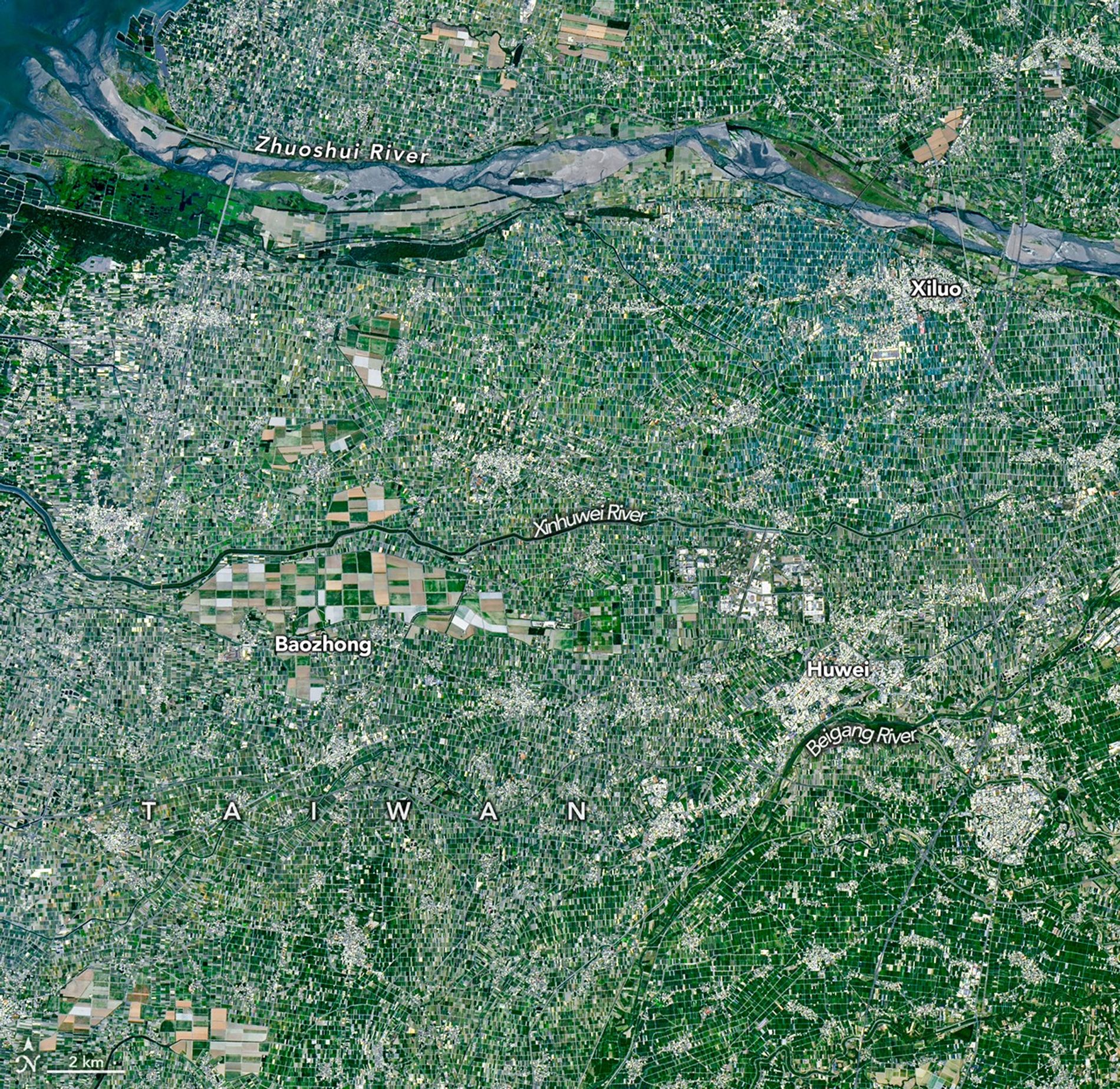
The small plot size is apparent in this satellite image of farmland in Yunlin County in southwestern Taiwan, one of the island’s most productive agricultural areas. The small size of farms is partly a result of past policies that limited the size of farms and partly a byproduct of cultural traditions that often lead to the division of farms into smaller parcels as property is passed from one generation to the next.
Located along the floodplains of the Zhoushui and Beigang rivers, Yunlin County is mostly flat, has fertile soils, and enjoys easy access to irrigation water. The county, one of Taiwan’s main agricultural hubs, is known for producing a wide range of crops, including rice, sweet potatoes, peanuts, corn, sugarcane, garlic, scallions, coffee, fruit trees, and leafy greens. Farms in the county also raise millions of pigs, the most of any county in Taiwan.
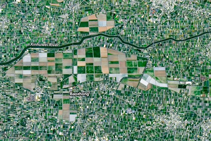
Most crops in Yunlin County are grown in small rectangular plots defined by roadways and networks of irrigation canals. The exception is sugarcane, which was grown widely in the county in the early 1900s when Japan controlled Taiwan and established an expansive network of sugarcane plantations in the southwestern part of the country. These plantations were consolidated into Taiwan Sugar Corporation after the conclusion of World War II, and the large plot sizes in the farmland north of Baozhong in the image above persist as a legacy of this period.
While the amount of sugarcane cultivated in Taiwan has declined in recent decades and many of the fields have transitioned to other crops, Taiwan Sugar Corporation still raises sugarcane around Baozhong. The company operates a railway that transports harvested cane to nearby Huwei, site of one of just a few remaining sugar refineries on the island. While Taiwan also once had a large network of sugar railways that serviced thousands of kilometers of track and dozens of sugar refineries, the line that serves Huwei is the only one on the island that remains active.
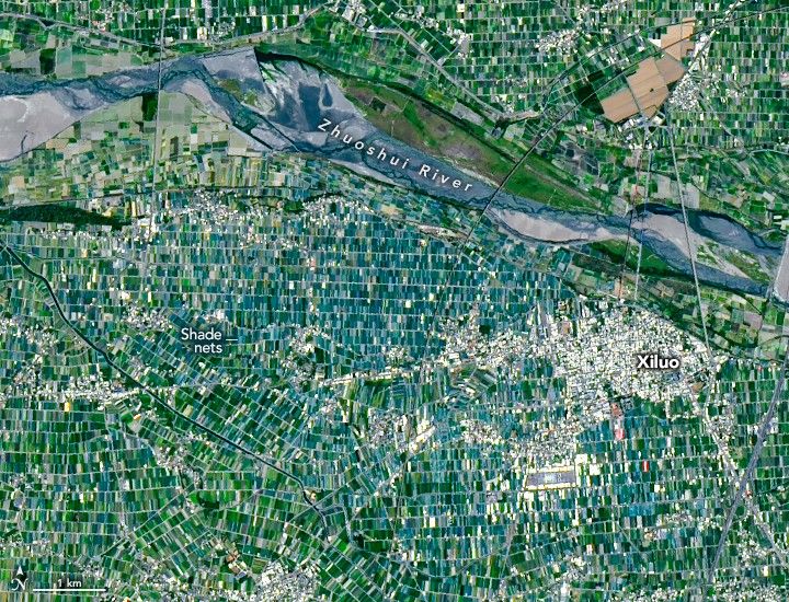
Another area that stands out in the mosaicked agricultural landscape of Yunlin is located around Xiluo (above). Here the fields take on an unusual greenish-blue hue, largely because of the ubiquity of shade nets. Farmers use the nets to protect crops from heat, sun, heavy rains, and pests. They’re generally deployed for specialty crops such as vegetables, fruit, and flowers. This area contrasts with the darker green region in the lower right of the first image, where rice is the dominant crop.
NASA Earth Observatory images by Michala Garrison, using Landsat data from the U.S. Geological Survey. Story by Adam Voiland.
References & Resources
- Britannica Yün-lin. Accessed April 23, 2026.
- Chen, Y.Y., et al. (2019) Reconstructing Taiwan’s land cover changes between 1904 and 2015 from historical maps and satellite images. Scientific Reports, 9, 3643.
- Kollar, J. (2019) Democratizing Control Over the Landscape: A Genealogy of Taiwan’s Infrastructural Bureaucracy. Accessed April 23, 2026.
- NASA Earth Observatory Food and Agriculture Collection. Accessed April 23, 2026.
- Nie, H., et al. (2025) The introduction and impact of food crops in Taiwan during the Japanese colonial period. Frontiers in Sustainable Food Systems, 9.
- Shih, C.M. & Yen, S.Y. (2009) The Transformation of the Sugar Industry and Land Use Policy in Taiwan, Journal of Asian Architecture and Building Engineering, 8(1), 41-48.
- Statbase (2023) Arable land area – Taiwan Province of China. Accessed April 23, 2026.
- Taiwan Agricultural Research Institute (2015) Development of map data for precision agriculture. Accessed April 23, 2026.
- Taiwan Agricultural Tourism (2026, March 31) Yunlin County. Accessed April 23, 2026.
- Taiwan Panorama (2019) The Home of Vegetables. Accessed April 23, 2026.
- Taiwan Today (2010, February 1) A Sweet Journey. Accessed April 23, 2026.
- World Bank Group (2023) Arable land (hectares per person). Accessed April 23, 2026.
- Yang, J.H., et al. (2024) Mapping Paddy Rice Fields by Sentinel-1 Time Series in Yunlin, Taiwan. International Journal of Remote Sensing, 46(12), 4533–4558.
You may also be interested in:
Stay up-to-date with the latest content from NASA as we explore the universe and discover more about our home planet.

The activity of herring around Vancouver Island in British Columbia brightened coastal waters enough to be detectable from space.

Winds blowing past the volcanic landmass near the Korean Peninsula created a trail of spiraling clouds, while murky water churned…

The Tongan volcano expanded its mid-Pacific real estate during its latest eruptive phase.


